
Heritage Walking Tour Booklet June 1982 by the Dover Heritage Group, Dover, NH, c. 1982.
In 1978, a group called Dover Tomorrow formed to promote the growth and prosperity of Dover. A subcommittee was tasked with promoting “appreciation of Dover’s heritage”. The Lively City Committee created the first Heritage Walk the next year. It was so popular that new tours were created every year, and held through 2007. By 1982, Dover’s historical society, the Northam Colonists, had taken over the research and creation of the Heritage Walking Tour Booklets. The information on the page below is a transcription of the original Heritage Walking Tour Booklet. The Library has a complete set of the Heritage Walking Tours if you would like to see the original booklets.
As one approaches Main Street and the Cocheco River from the Pacific Mills buildings the development influences of the early 1800’s collide head-on with those of the mid 1900’s. The area from the intersection of Main and Washington, once called Washington Square, to the corner of Main and Portland, at Lafayette Square, was once a vital commercial area. Beginning at the south end of Main Street, where the section of the mill housing Bayhead Products now stands, one would have encountered such establishments as that of Abel C. Smith, who dealt in crockery and glassware, Edmund C. & Wm. N. Andrews, merchants handling English and West India goods, and Thomas E. Sawyer practicing law. Ivory Varney also dealt in English and W. India goods with the offices of James Bartlett, Register of probate and attorney upstairs. At #3 Washington Square could be found James Richardson, Town Clerk and English/W. India goods merchant, with John H. White, attorney, upstairs. English and West India goods were also sold at the store of George Piper at #4 Washington square. Daniel M. Christie, attorney, practiced at #5. On Lafayette Square the Sawyer Building has dominated for 150 years. The land on which this building sits was given to Maj. Richard Waldron by grant of town dated June 1, 1642, and it remained in the possession of his family until March 1, 1822 when it was sold to Hosea Sawyer for $715. The structure was constructed during 1823 for the sum of $9,300, the itemization of which includes such entries as $3.67 for “rum for the workmen.” Tenants in this building included John P. Hale, a prominent attorney, and George W. Kittredge, M.D. both also boarded at Isaac A. Porter’s boarding house just around the corner at 2 Belknap (now Young) street. Hosea Sawyer kept store in the first floor rooms now occupied by Krans and Krans, while Elizabeth and Ruth Coffin, tailoresses and Mantua makers, occupied the first floor at 2 Portland Street. Joseph Cross, Recorder of Deeds, had an office upstairs. Next door at #4 Susan Webster and Eliza D. Morrison were also tailoresses and Mantua makers, while Lydia Ann Stevens, teacher of private school, occupied the first floor.
Other area businesses of record included Dominick Peduzzi, Jr., Lafayette Square confectioner; Charles Senter, provision store and barroom on Washington Square; Ebenezer Faxon, blacksmith, Main Street at the riverfront; and Abel Kimball, wine cellar on Perkins Street, near Main.
Orientation: References to the east and west refer to the left and right, respectively, as viewed on the outbound boat trip.
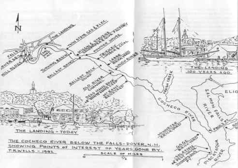
The present Dover Public Works Garage is located on the site of a soap factory.
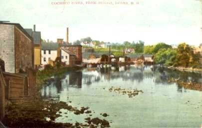
At the Public Service Company building on Cocheco Street was a deep water facility for unloading coal.
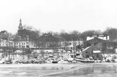
Immediately downriver from this building was an area called “the basin” where schooners were turned. Also this location was the Williams and Stevens Sandpaper and Glue Works, including a glass factory for making their own glue bottles.
The next stretch of river is virtually untouched today, but in years past a number of brickyards operated throughout the area. To the west is a pile of large rocks, used as ballast in the schooners which traveled the river.
On the east, but not visible from the boat, is the foundation of the powder house. Such structures were located some distance from the populated areas to avoid calamity in the case of untimely explosion. Trickey Brook enters from the east.
“The Dumps” appear to the west. This is an area where rocks were removed from the boats coming upriver in order to lighten them prior to entering the shallowest part of the navigable water. On returning to the bay, the rocks were retrieved and used as ballast. There are a number of distinct piles of these rocks each recognized as the property of a specific boat. To the east can be seen the foundation of the Labbe brickyard.
What appears to be an island, to the west, was created in 1823 when the river was dredged and the excess material piled here.
To the west are ledges, variously known as Dead Man’s Rock or White Man’s leap, followed by the remains of McKone’s brickyard.
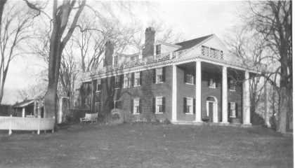
On the side of the hill to the east is Tidewater Farm, followed by the entrance of Fresh Creek into the Cocheco. Then through the trees, you may gain a glimpse of Three Rivers Farm, owned by the Rollins Estate.
Tidewater Farm
To the west stand the remains of pilings which mark the location of Minniter’s brickyard, which has been out of business since 1890.
Downriver just a bit more is the site of the Gage brickyard, then on the east the site of the Raitt brickyard, which is in Eliot, Maine.
The Salmon Falls River now joins the Cocheco to form the Piscataqua, which continues to the bay and the Atlantic Ocean. To the west, on Thomson’s Point, stood a rest house or sanitarium of sorts in the 1800’s.
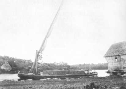
For the first 150 years of Dover’s existence – until after the close of the Revolutionary War- there was little river traffic on the Cocheco. At most people traveled back and forth between Dover and Portsmouth by rowboat and canoe. Using the tides to aid them, women frequently rowed to the better markets in Portsmouth during the early 1800’s. Larger vessels, some drawing more than 17 feet of water, ventured only as far up Thomson’s Point where their cargo was transferred to smaller craft for the trip up to the landing. This situation was to change and change rapidly. In 1825 Capt. Andrew Pierce and his brother-in law Capt. James Wentworth built the schooners “Dover Packet” and “Boston Packet” (packet being a catch-all term for the various vessels lying the river). Each measured about 65 tons and was to run constantly between Boston and Dover. With shipping to and from Dover flourishing a navigation company, the dispatch line of packets, was formed. This company eventually purchased nearly all the best vessels based in Dover. Soon operating seven vessels of its own, this company almost held an almost complete monopoly on river traffic on the Cocheco. Of those seven, four measured between 50 and 60 tons. Capt. Pierce, one of the principals of the dispatch line, estimated the value of all goods transported up and down the river to be $2,400,000 during the year 1842. The Cocheco Manufacturing Company was one of the better producers of revenue for the shipping lines, moving about $750,000 worth of goods over the water each year. Much of this, of course, was cotton being brought to the mills for processing. Gundalows operated independently of the Dispatch Line carried about one-half of the cotton upriver from larger ships in Portsmouth Harbor. The balance was brought up to the landing on schooners. These carriers would then reload and head back downriver, with a loaded gundalow requiring 41/2 hours of rowing to reach the Dover Point Bridge after leaving the landing. Competition, in the name of the Boston and Maine Railroad, appeared in 1842 heralding sharp decline in freight carried over water. Dover’s focus had begun to shift from the grace and beauty of watercraft to the power of iron horse.
Gundalow
The riverfront was once an area of thriving commerce. On the river near Washington Square were three stores, including that of William Hale, built in 1796 by William and Samuel Hale. The mill building occupied by Bayhead Products now occupies this site. Just south of the site of the lower Washington Street Bridge was Perkins Wharf, while north of the bridge, along Water Street, one would have found three stores and a house on the west side, four houses along the east side, plus three stores along the riverfront east of these houses. Along Belknap (now Young) street were four houses on the south side and two houses and a store on the north side. At the foot of Belknap street was Young’s Tannery. Between this point and the landing was a distillery, which was situated on the site of the gas works, recently vacated by Northern Utilities. Cocheco Street, where George’s Marina now provides public access to the river, was then called Flagg’s Road, in that it was the route to the farm of Capt. William Flagg at Three Rivers.
The future of the waterfront/ landing area looks brighter today than at any time in the last 150 years. Multi- use development of the Pacific Mills buildings is in the planning stages, with a combination of retail, commercial, residential, and light industrial uses a real possibility. Various city agencies are considering a number of changes in regulations governing the use of the waterfront and adjacent central business district which may well signal the end of years of neglect of this valuable resource – and the rebirth of the Cocheco River as a centerpiece for the city of Dover.
Some vessels owned by The Dispatch Line: Vessels owned in part by the line:
“William Tell” “The Charles Henry”
Capt. Daniel Trefethen John Smith 2nd, Master
“William Penn” “Dover Packet”
Capt. Archelaus Trefethen Tristam Coffin
“The Peirce” “Robert Rantoul, Jr.”
Capt. John Card T.N. Porter
“The December” “The Washington”
Capt. Clark Paul James B. Guppy
“The Lafayette”
Capt. James Sterling
“The Cocheco”