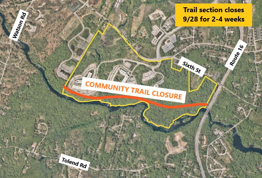
Since the mid-1990’s, the City of Dover has been actively planning and acquiring right-of-ways for a Community Trail Project. It is completed three phases since opening in 2011, with the fourth phase under design for future expansion.
The Dover Master Plan recommends a community trail to provide both recreation and alternative transportation opportunities for Dover’s citizens.
The trail follows a former railroad bed through much of the City and provide public access to protected greenways along the Cochecho and Bellamy Rivers
The in-town section of the trail provides a pedestrian and bicycle friendly connection between downtown, (with a trailhead at the City’s Transportation Center) the Dover Middle and High School campuses and Bellamy Park.
Rural extensions of the trail will provide opportunities for bicycling, hiking, bird watching, and fishing where the trail follows the Cochecho and Bellamy Rivers. A portion of the trail parallels Sixth Street, providing an alternative transportation linkage to Measured Progress, the former Liberty Mutual campus, and other employment centers in the Enterprise Park area.
Community Input through Trail Advisory Committee
Interested in the trail? Please come and join the Community Trail Advisory Committee!
The Community Trail Advisory Committee grew out of the Community Trail Design Group that was formed in June 2005 to address the concerns of Dover residents, and in particular, abutting property owners, to the redevelopment of the former railroad corridor as a multi-use community
trail resulted in report recommending everything from design specifications to how the trail should be operated by the City.
The Community Trail Advisory Committee typically meets the first Tuesday of the month at 5:30 p.m. in the First Floor Conference Room at City Hall. For more updates, follow us on Facebook: Dover Community Trail. Contact City Planner Erin Bassegio for more information.
Voyage Mark II Solar System Exhibit
Dover Community Trail hosts Voyage Mark II Solar System Exhibit, which is a highly accurate 1 to 10-billion scale model of the Solar System along the Dover Community Trail.
This is a permanent installation and it is a joint initiative between the Dover School District, Department of Planning and Community Development, and Community Trail Advisory Committee, with installation completed by the Community Services Department.
The Sun can be found at the Fisher Street Trailhead and the exhibit moves south along the Community Trail where the planets and moons of our Solar System can be viewed. The end of the exhibit, where the dwarf planet Pluto can be found, is located at the Rutland Street Trailhead.
For an interactive Solar System activity for use on the Community Trail, click here.
Phase IV — Current Expansion Project
In 2016, staff applied for the next round of TAP funding to add further extensions to connect the trail from Rutland and Central Avenue to the Knox Marsh Road, through the Middle and High School complex and Bellamy Park. Check out the rough map and general idea here: Phase IV Map.
On June 27, 2023, a discussion and public hearing was held on the Phase IV proposed extension. To review the presentation, and photos of the proposed trail area, click here.
In 2024, Planning staff worked with consultant partner, Fuss & O'Neill, on the completion of a draft engineering report for Phase IV of the Community Trail. To review the draft report, click here.
In Sept. 2026, the City Council will consider approving the final design for the Phase IV expansion.
Natural Resource Protection
Protecting natural habitat or greenways along the Cochecho and Bellamy Rivers has been a Dover Master Plan goal since the 1970’s. With the establishment of a Conservation Fund in 1999, the City of Dover provided a source of money to actively protect, either through purchase of land or development rights (through the use of conservation easements), land with significant natural resource value.
The Dover Conservation Commission and Open Lands Committee have focused their land protection efforts along the Bellamy and Cochecho Rivers. The Community Trail provides public access to these greenways with more planned.
Portions of the greenway and the associated trail system, between Fourth Street and Watson Road have been either acquired by land purchase or negotiated with landowners.
The Cochecho River Conservation Area, located along the northern side of the river between Whittier Street and Beckwith Park (off Hillside Drive), was purchased by the City with assistance from the New Hampshire Land and Community Heritage Investment Program. This area is open to the public. For information about Dover’s land protection efforts, contact the Open Lands Committee, through the City Planning Department: 603-516-6008 or e-mail Open Lands Committee
Adopt-a-Trail Section
If interested in cleaning up or adopting a trail section, please email City Planner Erin Bassegio for more information.
Area trail guides and links